Filtered by tag: Land Use Remove Filter

Huntersville Adopts Land Development Fee Schedule

Posted June 6, 2019

As it prepares to take over development plan review from Mecklenburg County on July 1st, the Town of Huntersville has amended its fee schedule to include the current (FY 2018) LUESA fees for land development plan review, bond maintenance and other related services. The fees are substantially lower than those proposed by Mecklenburg County in FY 2019 and 2020, which will increase more than 200% over a two-year period.

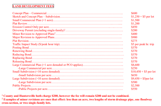
The main services the Town will take over from LUESA include development plan review; zoning, development and erosion control inspections; and bond administration. Five new positions have been created to provide these services, and the Town expects to have them in place within the next two months. The positions include a Street Inspector, an Erosion Control Inspector, a Bond Administrator, a Stormwater Plan Review and a Zoning Inspector.

Read More

Mecklenburg County Property Revaluations Online Now

Posted on January 28, 2019.

Originally posted by REBIC.

The 2019 Mecklenburg County Property Revaluation is complete, and property valuations are now online at the Assessor’s website.  Look for your Notice of 2019 Real Estate Assessed Value in your mailbox in late January 2019, and remember that this Notice is NOT a bill. Your property tax bill will be determined by the tax rates adopted by Mecklenburg County and the City of Charlotte later this year (probably around July).

You can also use the tools on the County website to file an informal appeal if you think your property has been improperly valued. If you disagree with the results of your Informal Review Request, you have a right to file a Formal Appeal to the Board of Equalization and Review. You may request an appeal any time prior to the adjournment of the Board of Equalization and Review or within 30 days of your Notice of 2019 Assessed Value. All requests for appeal must be made in writing and on the proper form.

Read More

Matthews Considering Small Area Plan Zoning Overlay Districts

Posted on June 22, 2018

The Matthews Town Board this week held a public hearing on a proposal to create a new Zoning Overlay District that would make the land use and development policies in three Small Area Plans enforceable on all new development, regardless of whether or not a rezoning is involved.

REBIC spoke against the proposal, as did a small group of property owners who shared our concerns about the restrictions the Overlay would place on their property. The Overlay would impact all parcels in three Small Area Plans adopted by the Town between 2014 and 2017:

While a Land Use Plan serves a policy guide, a zoning overlay district has the force of law on all property in its defined geography, and supersedes any zoning rights in the underlying district. The proposed Overlay District would incorporate policies ranging from building design to lot setbacks, and apply to both new development and redevelopment in all three Small Area Plan geographies.

Read More

From Blighted Brownfield to Thriving Infill Industrial Park

Posted on May 23, 2018

By: Bill Mosher and Ann Sperling

All photos courtesy of Trammell Crow Company
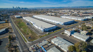
Long-term planning and collaboration among various partners across multiple jurisdictions have been key to creating a new industrial park in Denver’s Globeville neighborhood.

More than a century ago, the Asarco Globe Plant was operating as a metal smelting facility, employing nearly 3,000 Coloradans in Denver’s culturally rich Globeville neighborhood. Over the years, an array of industrial processes and uncontrolled disposal on-site contaminated the groundwater and soil with heavy metals. This contamination resulted in the property being identified as a brownfield site, and decades of investigation and remediation began.

When Asarco finally closed the plant entirely in 2006, the community was left with a blighted, abandoned and fenced 77.5-acre site. Land developer EnviroFinance Group LLC (EFG), working closely with the Colorado Department of Public Health and Environment (CDPHE), the U.S. Environmental Protection Agency (EPA), and Adams and Denver counties, managed the site’s environmental cleanup, achieving regulatory closure in June 2015. (Ongoing monitoring will continue for several more quarterly testing periods.)

Click here to read more.

City Releases TOD Ordinance Draft, Seeks Feedback from Development Industry

Posted on February 26, 2018

The City of Charlotte has released a draft of its Transit-Oriented Development A (TOD-A) ordinance, which would allow higher-density, mixed-used development within a quarter-mile of transit stations like the CATS Blue Line.

TOD-A is the first of at least 4 transit-oriented zoning districts that the Planning Department plans to unveil in the next few months, and is intended to accommodate the highest-intensity development along the transit corridor, with allowable building heights as tall as 250′.

After setting base densities and building standards, the ordinance uses a voluntary points system to incentivize developers to meet aesthetic design, open space and affordable housing objectives through allowances for greater building heights.

Read More

Charlotte Place Types and Unified Development Ordinance Needs Your Help

Posted on January 30, 2018

The Charlotte-Mecklenburg Planning Department has been diligently working on Charlotte Place Types and Unified Development Ordinance (UDO), a city-wide effort aimed at updating the policies and regulations that guide growth and development in our community. The project is scheduled to meet some major milestones in 2018 with a draft Place Types Policy Document ready for public review in August and adoption of new Transit Oriented Development (TOD) zoning districts expected in December. The success of this project is dependent upon receiving input all our community stakeholders and we believe your organization can help us reach an important audience. Therefore, would you please take a minute to:

U.S. House Approves Brownfields Legislation

Posted on December 27, 2017

On November 30, 2017, the U.S. House of Representative passed H.R. 3017, the Brownfields Enhancement, Economic Redevelopment and Reauthorization Act of 2017, which would allow up to $250 million annually to clean up brownfield sites during 2018-2022. The legislation, sponsored by Congressman David McKinley (R-WV), seeks to assist communities in restoring the contaminated land to productive use.

Click here to read the full article.

Concord to Host Drop-In Session on Proposed Land Use Plan

Posted on October 9, 2017

The City of Concord invites the public to get the first glimpse into the policies and maps that will guide the development of the community over the next 10-15 years. The 2030 Land Use Plan public input session is scheduled for 6:30 p.m. on Tuesday, October 10 CFA Village Suite 75 located at 280 Concord Parkway N.

With the assistance of Tindale Oliver, Planning and Neighborhood Development staff have been working to update the City's Land Use Plan to provide the framework for land use and development through the year 2030. The existing Land Use Plan, referred to as the 2015 Land Use Plan, was created in 2004 and updated in 2007.

The process is updating a land use map and supporting text document that contains data, specific goals, and policy recommendations focused on land use and development. The final plan will also guide City officials as they develop future budgets, plan infrastructure and other services, make important land use decisions, and revise current policies within the Concord Development Ordinance.

Read More